|
|
|||||||||||||||||
| Point ID: 6457 | Downloads | Plots | Site Data | Code: 8059 |
|
|
|||||||||||||||||
| Download | |
|---|---|
| Site Descriptor Information | Site Time Series Data |
| Link to all available data | |
| View: | Time Series | All |
| Units: | mm |
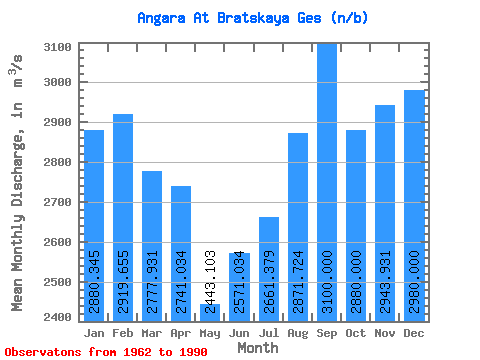
| Statistic | Jan | Feb | Mar | Apr | May | Jun | Jul | Aug | Sep | Oct | Nov | Dec | Annual |
|---|---|---|---|---|---|---|---|---|---|---|---|---|---|
| Mean | 2880.34 | 2919.66 | 2777.93 | 2741.03 | 2443.10 | 2571.03 | 2661.38 | 2871.72 | 3100.00 | 2880.00 | 2943.93 | 2980.00 | 2814.18 |
| Standard Deviation | 741.80 | 830.31 | 769.27 | 686.43 | 514.91 | 386.59 | 435.90 | 645.11 | 705.89 | 620.10 | 728.15 | 691.99 | 494.15 |
| Min | 1000.00 | 1450.00 | 1270.00 | 1770.00 | 1710.00 | 1990.00 | 1740.00 | 1810.00 | 2070.00 | 920.00 | 744.00 | 930.00 | 1929.50 |
| Max | 3930.00 | 4290.00 | 4010.00 | 4090.00 | 3530.00 | 3430.00 | 3560.00 | 4820.00 | 5150.00 | 3980.00 | 3840.00 | 4130.00 | 3680.00 |
| Coefficient of Variation | 0.26 | 0.28 | 0.28 | 0.25 | 0.21 | 0.15 | 0.16 | 0.23 | 0.23 | 0.21 | 0.25 | 0.23 | 0.18 |
 Return to R-Arctic Net Home Page