|
|
|||||||||||||||||
| Point ID: 6342 | Downloads | Plots | Site Data | Code: 3821 |
|
|
|||||||||||||||||
| Download | |
|---|---|
| Site Descriptor Information | Site Time Series Data |
| Link to all available data | |
| View: | Time Series | All |
| Units: | m3/s |
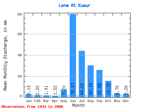
| Statistic | Jan | Feb | Mar | Apr | May | Jun | Jul | Aug | Sep | Oct | Nov | Dec | Annual |
|---|---|---|---|---|---|---|---|---|---|---|---|---|---|
| Mean | 3.13 | 2.24 | 1.91 | 1.52 | 7.20 | 78.97 | 44.02 | 30.14 | 25.88 | 15.72 | 3.75 | 3.26 | 217.69 |
| Standard Deviation | 0.72 | 0.67 | 0.69 | 0.56 | 8.17 | 11.08 | 9.00 | 7.08 | 6.91 | 4.04 | 0.91 | 0.74 | 26.25 |
| Min | 1.69 | 1.02 | 0.76 | 0.46 | 0.62 | 47.36 | 27.87 | 14.22 | 14.61 | 8.89 | 2.04 | 1.87 | 165.34 |
| Max | 4.62 | 3.71 | 4.01 | 2.98 | 35.27 | 110.93 | 64.15 | 47.28 | 43.20 | 24.91 | 6.60 | 5.31 | 299.42 |
| Coefficient of Variation | 0.23 | 0.30 | 0.36 | 0.37 | 1.13 | 0.14 | 0.20 | 0.23 | 0.27 | 0.26 | 0.24 | 0.23 | 0.12 |
 Return to R-Arctic Net Home Page