|
|
|||||||||||||||||
| Point ID: 6284 | Downloads | Plots | Site Data | Code: 3389 |
|
|
|||||||||||||||||
| Download | |
|---|---|
| Site Descriptor Information | Site Time Series Data |
| Link to all available data | |
| View: | Time Series | All |
| Units: | m3/s |
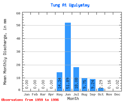
| Statistic | Jan | Feb | Mar | Apr | May | Jun | Jul | Aug | Sep | Oct | Nov | Dec | Annual |
|---|---|---|---|---|---|---|---|---|---|---|---|---|---|
| Mean | 0.00 | 0.00 | 0.00 | 0.00 | 14.33 | 51.89 | 18.07 | 9.74 | 9.24 | 2.29 | 0.16 | 0.02 | 106.69 |
| Standard Deviation | 0.00 | 0.00 | 0.00 | 0.00 | 11.02 | 21.74 | 17.49 | 11.90 | 7.45 | 2.05 | 0.20 | 0.04 | 43.85 |
| Min | 0.00 | 0.00 | 0.00 | 0.00 | 0.29 | 12.12 | 1.97 | 0.12 | 0.10 | 0.05 | 0.01 | 0.00 | 43.68 |
| Max | 0.01 | 0.01 | 0.01 | 0.01 | 49.00 | 107.18 | 61.45 | 56.38 | 27.46 | 7.38 | 1.00 | 0.20 | 225.51 |
| Coefficient of Variation | 2.26 | 3.06 | 3.33 | 3.71 | 0.77 | 0.42 | 0.97 | 1.22 | 0.81 | 0.90 | 1.29 | 1.85 | 0.41 |
 Return to R-Arctic Net Home Page