|
|
|||||||||||||||||
| Point ID: 6284 | Downloads | Plots | Site Data | Code: 3389 |
|
|
|||||||||||||||||
| Download | |
|---|---|
| Site Descriptor Information | Site Time Series Data |
| Link to all available data | |
| View: | Time Series | All |
| Units: | mm |
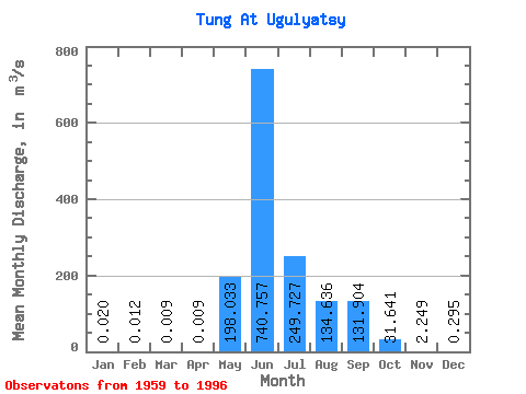
| Statistic | Jan | Feb | Mar | Apr | May | Jun | Jul | Aug | Sep | Oct | Nov | Dec | Annual |
|---|---|---|---|---|---|---|---|---|---|---|---|---|---|
| Mean | 0.02 | 0.01 | 0.01 | 0.01 | 198.03 | 740.76 | 249.73 | 134.64 | 131.90 | 31.64 | 2.25 | 0.29 | 125.08 |
| Standard Deviation | 0.04 | 0.04 | 0.03 | 0.04 | 152.26 | 310.35 | 241.63 | 164.39 | 106.29 | 28.32 | 2.91 | 0.55 | 51.41 |
| Min | 0.00 | 0.00 | 0.00 | 0.00 | 3.99 | 173.00 | 27.20 | 1.64 | 1.36 | 0.71 | 0.08 | 0.00 | 51.21 |
| Max | 0.16 | 0.14 | 0.14 | 0.16 | 677.00 | 1530.00 | 849.00 | 779.00 | 392.00 | 102.00 | 14.30 | 2.74 | 264.38 |
| Coefficient of Variation | 2.26 | 3.06 | 3.33 | 3.71 | 0.77 | 0.42 | 0.97 | 1.22 | 0.81 | 0.90 | 1.29 | 1.85 | 0.41 |
 Return to R-Arctic Net Home Page