|
|
|||||||||||||||||
| Point ID: 6279 | Downloads | Plots | Site Data | Code: 3366 |
|
|
|||||||||||||||||
| Download | |
|---|---|
| Site Descriptor Information | Site Time Series Data |
| Link to all available data | |
| View: | Time Series | All |
| Units: | m3/s |
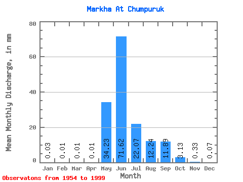
| Statistic | Jan | Feb | Mar | Apr | May | Jun | Jul | Aug | Sep | Oct | Nov | Dec | Annual |
|---|---|---|---|---|---|---|---|---|---|---|---|---|---|
| Mean | 0.03 | 0.01 | 0.01 | 0.01 | 34.23 | 71.62 | 22.07 | 12.23 | 11.89 | 3.13 | 0.33 | 0.07 | 156.84 |
| Standard Deviation | 0.02 | 0.01 | 0.01 | 0.03 | 24.91 | 30.20 | 18.32 | 15.09 | 8.45 | 2.22 | 0.23 | 0.05 | 46.71 |
| Min | 0.00 | 0.00 | 0.00 | 0.00 | 0.34 | 24.04 | 1.65 | 0.56 | 0.85 | 0.54 | 0.06 | 0.00 | 76.49 |
| Max | 0.07 | 0.05 | 0.04 | 0.22 | 115.36 | 155.45 | 80.65 | 84.05 | 32.15 | 9.77 | 1.16 | 0.22 | 271.21 |
| Coefficient of Variation | 0.63 | 0.86 | 1.06 | 3.02 | 0.73 | 0.42 | 0.83 | 1.23 | 0.71 | 0.71 | 0.69 | 0.65 | 0.30 |
 Return to R-Arctic Net Home Page