|
|
|||||||||||||||||
| Point ID: 6279 | Downloads | Plots | Site Data | Code: 3366 |
|
|
|||||||||||||||||
| Download | |
|---|---|
| Site Descriptor Information | Site Time Series Data |
| Link to all available data | |
| View: | Time Series | All |
| Units: | mm |
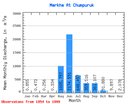
| Statistic | Jan | Feb | Mar | Apr | May | Jun | Jul | Aug | Sep | Oct | Nov | Dec | Annual |
|---|---|---|---|---|---|---|---|---|---|---|---|---|---|
| Mean | 0.85 | 0.47 | 0.26 | 0.33 | 1005.80 | 2174.59 | 648.46 | 359.52 | 361.11 | 91.88 | 9.90 | 2.08 | 391.11 |
| Standard Deviation | 0.54 | 0.41 | 0.27 | 1.01 | 732.00 | 916.84 | 538.45 | 443.40 | 256.67 | 65.34 | 6.88 | 1.36 | 116.47 |
| Min | 0.00 | 0.00 | 0.00 | 0.00 | 9.95 | 730.00 | 48.50 | 16.30 | 25.90 | 15.90 | 1.93 | 0.04 | 190.74 |
| Max | 2.11 | 1.56 | 1.25 | 6.67 | 3390.00 | 4720.00 | 2370.00 | 2470.00 | 976.00 | 287.00 | 35.20 | 6.39 | 676.32 |
| Coefficient of Variation | 0.63 | 0.86 | 1.06 | 3.02 | 0.73 | 0.42 | 0.83 | 1.23 | 0.71 | 0.71 | 0.69 | 0.65 | 0.30 |
 Return to R-Arctic Net Home Page