|
|
|||||||||||||||||
| Point ID: 6268 | Downloads | Plots | Site Data | Other Close Sites | Code: 3334 |
|
|
|||||||||||||||||
| Download | |
|---|---|
| Site Descriptor Information | Site Time Series Data |
| Link to all available data | |
| View: | Time Series | All |
| Units: | m3/s |
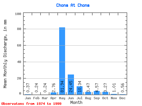
| Statistic | Jan | Feb | Mar | Apr | May | Jun | Jul | Aug | Sep | Oct | Nov | Dec | Annual |
|---|---|---|---|---|---|---|---|---|---|---|---|---|---|
| Mean | 0.37 | 0.24 | 0.24 | 2.76 | 81.92 | 24.45 | 10.34 | 3.47 | 4.58 | 3.27 | 1.01 | 0.56 | 130.58 |
| Standard Deviation | 0.21 | 0.14 | 0.13 | 9.24 | 26.58 | 15.09 | 15.81 | 1.79 | 2.31 | 1.69 | 0.58 | 0.24 | 37.71 |
| Min | 0.07 | 0.06 | 0.10 | 0.11 | 0.55 | 0.36 | 1.34 | 1.23 | 1.58 | 0.30 | 0.46 | 0.20 | 15.34 |
| Max | 0.97 | 0.63 | 0.69 | 45.30 | 115.79 | 56.78 | 81.23 | 7.61 | 10.47 | 7.82 | 3.13 | 1.35 | 187.81 |
| Coefficient of Variation | 0.57 | 0.56 | 0.55 | 3.35 | 0.32 | 0.62 | 1.53 | 0.52 | 0.50 | 0.52 | 0.58 | 0.44 | 0.29 |
| Other Close Sites | ||||||
|---|---|---|---|---|---|---|
| PointID | Latitude | Longitude | Drainage Area | Source | Name | |
| 6269 | "Chona At Ust'-Markhaya" | 61.98 | 1042418 | SHI | 274.00 | |
 Return to R-Arctic Net Home Page