|
|
|||||||||||||||||
| Point ID: 6268 | Downloads | Plots | Site Data | Other Close Sites | Code: 3334 |
|
|
|||||||||||||||||
| Download | |
|---|---|
| Site Descriptor Information | Site Time Series Data |
| Link to all available data | |
| View: | Time Series | All |
| Units: | mm |
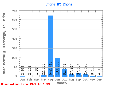
| Statistic | Jan | Feb | Mar | Apr | May | Jun | Jul | Aug | Sep | Oct | Nov | Dec | Annual |
|---|---|---|---|---|---|---|---|---|---|---|---|---|---|
| Mean | 2.93 | 2.10 | 1.88 | 22.38 | 642.41 | 198.05 | 81.08 | 27.21 | 37.06 | 25.63 | 8.16 | 4.39 | 86.89 |
| Standard Deviation | 1.67 | 1.17 | 1.03 | 74.91 | 208.40 | 122.23 | 123.98 | 14.03 | 18.69 | 13.29 | 4.71 | 1.92 | 25.09 |
| Min | 0.56 | 0.50 | 0.78 | 0.89 | 4.29 | 2.96 | 10.50 | 9.66 | 12.80 | 2.36 | 3.69 | 1.55 | 10.21 |
| Max | 7.63 | 5.41 | 5.40 | 367.00 | 908.00 | 460.00 | 637.00 | 59.70 | 84.80 | 61.30 | 25.40 | 10.60 | 124.97 |
| Coefficient of Variation | 0.57 | 0.56 | 0.55 | 3.35 | 0.32 | 0.62 | 1.53 | 0.52 | 0.50 | 0.52 | 0.58 | 0.44 | 0.29 |
| Other Close Sites | ||||||
|---|---|---|---|---|---|---|
| PointID | Latitude | Longitude | Drainage Area | Source | Name | |
| 6269 | "Chona At Ust'-Markhaya" | 61.98 | 1042418 | SHI | 274.00 | |
 Return to R-Arctic Net Home Page