|
|
|||||||||||||||||
| Point ID: 6241 | Downloads | Plots | Site Data | Code: 3247 |
|
|
|||||||||||||||||
| Download | |
|---|---|
| Site Descriptor Information | Site Time Series Data |
| Link to all available data | |
| View: | Time Series | All |
| Units: | m3/s |
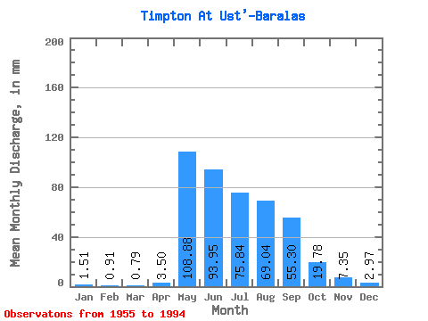
| Statistic | Jan | Feb | Mar | Apr | May | Jun | Jul | Aug | Sep | Oct | Nov | Dec | Annual |
|---|---|---|---|---|---|---|---|---|---|---|---|---|---|
| Mean | 1.51 | 0.92 | 0.79 | 3.50 | 108.86 | 93.95 | 75.83 | 69.03 | 55.30 | 19.78 | 7.35 | 2.97 | 436.05 |
| Standard Deviation | 0.78 | 0.48 | 0.46 | 5.42 | 28.40 | 40.81 | 32.08 | 35.72 | 22.30 | 8.02 | 4.92 | 1.77 | 80.24 |
| Min | 0.51 | 0.31 | 0.29 | 0.38 | 53.56 | 34.49 | 16.17 | 16.37 | 18.42 | 6.72 | 2.32 | 1.01 | 277.08 |
| Max | 3.77 | 2.09 | 1.94 | 23.19 | 173.77 | 206.58 | 198.33 | 147.79 | 102.12 | 41.08 | 29.43 | 11.10 | 641.55 |
| Coefficient of Variation | 0.52 | 0.53 | 0.58 | 1.54 | 0.26 | 0.43 | 0.42 | 0.52 | 0.40 | 0.41 | 0.67 | 0.60 | 0.18 |
 Return to R-Arctic Net Home Page