|
|
|||||||||||||||||
| Point ID: 6241 | Downloads | Plots | Site Data | Code: 3247 |
|
|
|||||||||||||||||
| Download | |
|---|---|
| Site Descriptor Information | Site Time Series Data |
| Link to all available data | |
| View: | Time Series | All |
| Units: | mm |
| Statistic | Jan | Feb | Mar | Apr | May | Jun | Jul | Aug | Sep | Oct | Nov | Dec | Annual |
|---|---|---|---|---|---|---|---|---|---|---|---|---|---|
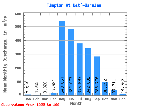
| Mean | 7.52 | 5.00 | 3.93 | 17.98 | 540.67 | 482.08 | 376.60 | 342.83 | 283.78 | 98.23 | 37.71 | 14.76 | 183.76 |
| Standard Deviation | 3.88 | 2.64 | 2.29 | 27.79 | 141.04 | 209.43 | 159.32 | 177.40 | 114.42 | 39.82 | 25.23 | 8.80 | 33.81 |
| Min | 2.53 | 1.71 | 1.46 | 1.96 | 266.00 | 177.00 | 80.30 | 81.30 | 94.50 | 33.40 | 11.90 | 5.04 | 116.77 |
| Max | 18.70 | 11.40 | 9.61 | 119.00 | 863.00 | 1060.00 | 985.00 | 734.00 | 524.00 | 204.00 | 151.00 | 55.10 | 270.36 |
| Coefficient of Variation | 0.52 | 0.53 | 0.58 | 1.54 | 0.26 | 0.43 | 0.42 | 0.52 | 0.40 | 0.41 | 0.67 | 0.60 | 0.18 |
 Return to R-Arctic Net Home Page