|
|
|||||||||||||||||
| Point ID: 6235 | Downloads | Plots | Site Data | Code: 3225 |
|
|
|||||||||||||||||
| Download | |
|---|---|
| Site Descriptor Information | Site Time Series Data |
| Link to all available data | |
| View: | Time Series | All |
| Units: | m3/s |
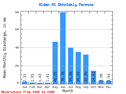
| Statistic | Jan | Feb | Mar | Apr | May | Jun | Jul | Aug | Sep | Oct | Nov | Dec | Annual |
|---|---|---|---|---|---|---|---|---|---|---|---|---|---|
| Mean | 2.31 | 1.56 | 1.43 | 1.41 | 46.24 | 78.76 | 39.86 | 35.23 | 32.20 | 14.61 | 3.98 | 3.54 | 260.64 |
| Standard Deviation | 0.66 | 0.45 | 0.40 | 0.44 | 18.08 | 23.00 | 14.69 | 13.35 | 11.98 | 5.27 | 1.24 | 1.03 | 45.97 |
| Min | 1.30 | 0.87 | 0.76 | 0.75 | 6.20 | 32.78 | 16.41 | 10.73 | 13.56 | 6.62 | 1.93 | 1.58 | 172.56 |
| Max | 4.80 | 3.22 | 2.64 | 2.78 | 86.49 | 143.22 | 75.03 | 73.46 | 66.06 | 30.95 | 8.32 | 8.08 | 367.73 |
| Coefficient of Variation | 0.28 | 0.29 | 0.28 | 0.31 | 0.39 | 0.29 | 0.37 | 0.38 | 0.37 | 0.36 | 0.31 | 0.29 | 0.18 |
 Return to R-Arctic Net Home Page