|
|
|||||||||||||||||
| Point ID: 6235 | Downloads | Plots | Site Data | Code: 3225 |
|
|
|||||||||||||||||
| Download | |
|---|---|
| Site Descriptor Information | Site Time Series Data |
| Link to all available data | |
| View: | Time Series | All |
| Units: | mm |
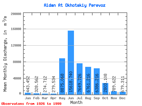
| Statistic | Jan | Feb | Mar | Apr | May | Jun | Jul | Aug | Sep | Oct | Nov | Dec | Annual |
|---|---|---|---|---|---|---|---|---|---|---|---|---|---|
| Mean | 443.45 | 328.56 | 274.71 | 279.53 | 8875.07 | 15618.74 | 7649.73 | 6761.22 | 6386.22 | 2803.11 | 789.62 | 679.31 | 4244.92 |
| Standard Deviation | 125.69 | 95.25 | 77.19 | 87.67 | 3469.51 | 4561.12 | 2819.44 | 2561.34 | 2376.55 | 1012.12 | 245.70 | 197.07 | 748.61 |
| Min | 249.00 | 183.00 | 145.00 | 149.00 | 1190.00 | 6500.00 | 3150.00 | 2060.00 | 2690.00 | 1270.00 | 382.00 | 304.00 | 2810.33 |
| Max | 922.00 | 678.00 | 506.00 | 551.00 | 16600.00 | 28400.00 | 14400.00 | 14100.00 | 13100.00 | 5940.00 | 1650.00 | 1550.00 | 5989.08 |
| Coefficient of Variation | 0.28 | 0.29 | 0.28 | 0.31 | 0.39 | 0.29 | 0.37 | 0.38 | 0.37 | 0.36 | 0.31 | 0.29 | 0.18 |
 Return to R-Arctic Net Home Page