|
|
|||||||||||||||||
| Point ID: 6214 | Downloads | Plots | Site Data | Code: 3163 |
|
|
|||||||||||||||||
| Download | |
|---|---|
| Site Descriptor Information | Site Time Series Data |
| Link to all available data | |
| View: | Time Series | All |
| Units: | m3/s |
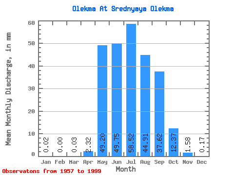
| Statistic | Jan | Feb | Mar | Apr | May | Jun | Jul | Aug | Sep | Oct | Nov | Dec | Annual |
|---|---|---|---|---|---|---|---|---|---|---|---|---|---|
| Mean | 0.02 | 0.00 | 0.03 | 2.32 | 49.20 | 49.75 | 58.51 | 44.91 | 37.62 | 12.37 | 1.58 | 0.17 | 254.85 |
| Standard Deviation | 0.02 | 0.01 | 0.16 | 5.46 | 28.46 | 40.33 | 51.90 | 27.43 | 23.80 | 7.94 | 1.52 | 0.17 | 96.04 |
| Min | 0.00 | 0.00 | 0.00 | 0.00 | 7.97 | 7.37 | 5.66 | 6.37 | 2.75 | 0.95 | 0.00 | 0.00 | 89.33 |
| Max | 0.08 | 0.03 | 1.03 | 24.60 | 132.10 | 181.37 | 304.42 | 112.72 | 112.58 | 41.78 | 7.64 | 0.89 | 537.32 |
| Coefficient of Variation | 1.02 | 1.78 | 6.25 | 2.35 | 0.58 | 0.81 | 0.89 | 0.61 | 0.63 | 0.64 | 0.96 | 1.00 | 0.38 |
 Return to R-Arctic Net Home Page