|
|
|||||||||||||||||
| Point ID: 6214 | Downloads | Plots | Site Data | Code: 3163 |
|
|
|||||||||||||||||
| Download | |
|---|---|
| Site Descriptor Information | Site Time Series Data |
| Link to all available data | |
| View: | Time Series | All |
| Units: | mm |
| Statistic | Jan | Feb | Mar | Apr | May | Jun | Jul | Aug | Sep | Oct | Nov | Dec | Annual |
|---|---|---|---|---|---|---|---|---|---|---|---|---|---|
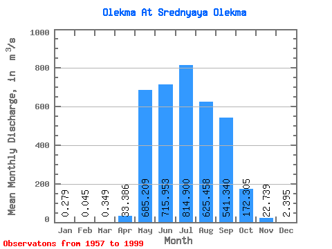
| Mean | 0.28 | 0.04 | 0.35 | 33.39 | 685.21 | 715.95 | 814.90 | 625.46 | 541.34 | 172.31 | 22.74 | 2.40 | 301.20 |
| Standard Deviation | 0.28 | 0.08 | 2.18 | 78.53 | 396.45 | 580.37 | 722.82 | 382.08 | 342.45 | 110.62 | 21.83 | 2.41 | 113.50 |
| Min | 0.00 | 0.00 | 0.00 | 0.00 | 111.00 | 106.00 | 78.80 | 88.70 | 39.60 | 13.30 | 0.05 | 0.00 | 105.57 |
| Max | 1.17 | 0.41 | 14.30 | 354.00 | 1840.00 | 2610.00 | 4240.00 | 1570.00 | 1620.00 | 582.00 | 110.00 | 12.40 | 635.04 |
| Coefficient of Variation | 1.02 | 1.78 | 6.25 | 2.35 | 0.58 | 0.81 | 0.89 | 0.61 | 0.63 | 0.64 | 0.96 | 1.00 | 0.38 |
 Return to R-Arctic Net Home Page