|
|
|||||||||||||||||
| Point ID: 6208 | Downloads | Plots | Site Data | Other Close Sites | Code: 3155 |
|
|
|||||||||||||||||
| Download | |
|---|---|
| Site Descriptor Information | Site Time Series Data |
| Link to all available data | |
| View: | Time Series | All |
| Units: | m3/s |
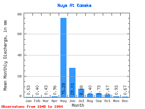
| Statistic | Jan | Feb | Mar | Apr | May | Jun | Jul | Aug | Sep | Oct | Nov | Dec | Annual |
|---|---|---|---|---|---|---|---|---|---|---|---|---|---|
| Mean | 0.53 | 0.40 | 0.43 | 0.96 | 75.27 | 28.01 | 8.08 | 3.40 | 3.73 | 2.67 | 0.93 | 0.67 | 124.73 |
| Standard Deviation | 0.19 | 0.21 | 0.22 | 1.32 | 24.48 | 18.41 | 5.83 | 2.96 | 3.47 | 2.21 | 0.47 | 0.28 | 32.66 |
| Min | 0.14 | 0.08 | 0.01 | 0.08 | 0.78 | 7.38 | 1.14 | 0.28 | 0.36 | 0.45 | 0.29 | 0.17 | 34.90 |
| Max | 0.95 | 1.26 | 1.14 | 7.31 | 129.78 | 73.11 | 28.15 | 12.75 | 19.01 | 12.43 | 2.57 | 1.39 | 205.25 |
| Coefficient of Variation | 0.35 | 0.51 | 0.51 | 1.37 | 0.33 | 0.66 | 0.72 | 0.87 | 0.93 | 0.83 | 0.51 | 0.42 | 0.26 |
| Other Close Sites | ||||||
|---|---|---|---|---|---|---|
| PointID | Latitude | Longitude | Drainage Area | Source | Name | |
| 6209 | "Nuya At Kurum" | 60.27 | 1367554 | SHI | 132.00 | |
| 6325 | "Nuya At Naakhara" | 60.45 | 1338820 | SHI | 244.00 | |
 Return to R-Arctic Net Home Page