|
|
|||||||||||||||||
| Point ID: 6325 | Downloads | Plots | Site Data | Other Close Sites | Code: 3574 |
|
|
|||||||||||||||||
| Download | |
|---|---|
| Site Descriptor Information | Site Time Series Data |
| Link to all available data | |
| View: | Time Series | All |
| Units: | m3/s |
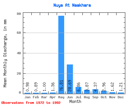
| Statistic | Jan | Feb | Mar | Apr | May | Jun | Jul | Aug | Sep | Oct | Nov | Dec | Annual |
|---|---|---|---|---|---|---|---|---|---|---|---|---|---|
| Mean | 0.98 | 0.90 | 1.00 | 1.36 | 76.80 | 28.69 | 6.86 | 3.87 | 4.37 | 2.96 | 1.61 | 1.21 | 134.65 |
| Standard Deviation | 0.33 | 0.33 | 0.42 | 0.74 | 28.93 | 18.10 | 5.77 | 2.64 | 3.66 | 2.02 | 0.74 | 0.37 | 34.45 |
| Min | 0.56 | 0.36 | 0.36 | 0.49 | 0.08 | 0.40 | 0.55 | 0.15 | 0.01 | 0.00 | 1.04 | 0.58 | 89.85 |
| Max | 1.56 | 1.59 | 1.92 | 3.44 | 121.20 | 60.22 | 21.36 | 9.05 | 12.62 | 7.72 | 3.53 | 1.78 | 201.26 |
| Coefficient of Variation | 0.33 | 0.36 | 0.42 | 0.54 | 0.38 | 0.63 | 0.84 | 0.68 | 0.84 | 0.68 | 0.46 | 0.30 | 0.26 |
| Other Close Sites | ||||||
|---|---|---|---|---|---|---|
| PointID | Latitude | Longitude | Drainage Area | Source | Name | |
| 6208 | "Nuya At Komaka" | 60.27 | 1367554 | SHI | 554.00 | |
| 6209 | "Nuya At Kurum" | 60.27 | 1367554 | SHI | 132.00 | |
 Return to R-Arctic Net Home Page