|
|
|||||||||||||||||
| Point ID: 6176 | Downloads | Plots | Site Data | Code: 3106 |
|
|
|||||||||||||||||
| Download | |
|---|---|
| Site Descriptor Information | Site Time Series Data |
| Link to all available data | |
| View: | Time Series | All |
| Units: | m3/s |
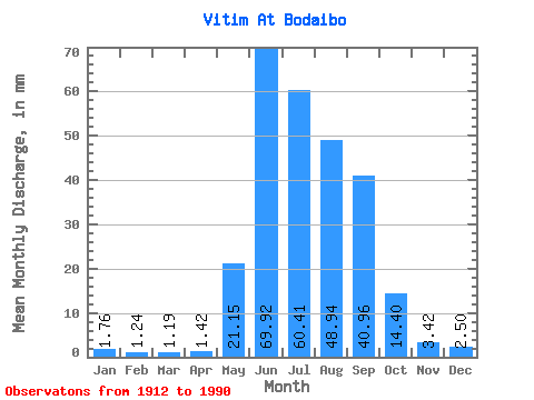
| Statistic | Jan | Feb | Mar | Apr | May | Jun | Jul | Aug | Sep | Oct | Nov | Dec | Annual |
|---|---|---|---|---|---|---|---|---|---|---|---|---|---|
| Mean | 1.77 | 1.25 | 1.19 | 1.42 | 21.14 | 69.92 | 60.40 | 48.93 | 40.96 | 14.40 | 3.42 | 2.50 | 264.95 |
| Standard Deviation | 0.48 | 0.36 | 0.34 | 0.52 | 10.06 | 22.90 | 26.84 | 23.73 | 21.64 | 5.75 | 0.85 | 0.64 | 61.33 |
| Min | 0.97 | 0.63 | 0.43 | 0.82 | 6.19 | 26.20 | 18.86 | 14.02 | 12.60 | 5.72 | 1.38 | 1.22 | 141.03 |
| Max | 3.66 | 2.73 | 2.42 | 3.61 | 66.09 | 123.05 | 143.55 | 116.05 | 109.25 | 38.59 | 5.60 | 4.02 | 439.44 |
| Coefficient of Variation | 0.27 | 0.29 | 0.29 | 0.36 | 0.48 | 0.33 | 0.44 | 0.48 | 0.53 | 0.40 | 0.25 | 0.26 | 0.23 |
 Return to R-Arctic Net Home Page