|
|
|||||||||||||||||
| Point ID: 6176 | Downloads | Plots | Site Data | Code: 3106 |
|
|
|||||||||||||||||
| Download | |
|---|---|
| Site Descriptor Information | Site Time Series Data |
| Link to all available data | |
| View: | Time Series | All |
| Units: | mm |
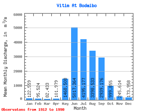
| Statistic | Jan | Feb | Mar | Apr | May | Jun | Jul | Aug | Sep | Oct | Nov | Dec | Annual |
|---|---|---|---|---|---|---|---|---|---|---|---|---|---|
| Mean | 122.56 | 95.52 | 82.43 | 101.98 | 1468.51 | 5017.36 | 4195.18 | 3398.53 | 2939.18 | 999.86 | 245.61 | 173.96 | 1561.51 |
| Standard Deviation | 33.36 | 27.54 | 23.99 | 37.03 | 698.41 | 1643.56 | 1863.91 | 1647.95 | 1553.17 | 399.58 | 61.28 | 44.43 | 361.45 |
| Min | 67.20 | 48.30 | 29.70 | 59.10 | 430.00 | 1880.00 | 1310.00 | 974.00 | 904.00 | 397.00 | 98.90 | 84.80 | 831.17 |
| Max | 254.00 | 208.00 | 168.00 | 259.00 | 4590.00 | 8830.00 | 9970.00 | 8060.00 | 7840.00 | 2680.00 | 402.00 | 279.00 | 2589.82 |
| Coefficient of Variation | 0.27 | 0.29 | 0.29 | 0.36 | 0.48 | 0.33 | 0.44 | 0.48 | 0.53 | 0.40 | 0.25 | 0.26 | 0.23 |
 Return to R-Arctic Net Home Page