|
|
|||||||||||||||||
| Point ID: 6170 | Downloads | Plots | Site Data | Code: 3096 |
|
|
|||||||||||||||||
| Download | |
|---|---|
| Site Descriptor Information | Site Time Series Data |
| Link to all available data | |
| View: | Time Series | All |
| Units: | m3/s |
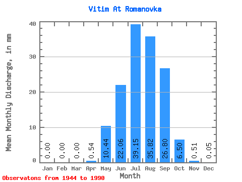
| Statistic | Jan | Feb | Mar | Apr | May | Jun | Jul | Aug | Sep | Oct | Nov | Dec | Annual |
|---|---|---|---|---|---|---|---|---|---|---|---|---|---|
| Mean | 0.00 | 0.00 | 0.00 | 0.54 | 10.44 | 22.06 | 39.15 | 35.82 | 26.80 | 6.50 | 0.51 | 0.05 | 140.94 |
| Standard Deviation | 0.00 | 0.00 | 0.00 | 1.04 | 8.05 | 24.22 | 34.38 | 31.22 | 23.49 | 5.12 | 0.34 | 0.07 | 80.76 |
| Min | 0.00 | 0.00 | 0.00 | 0.00 | 2.13 | 2.73 | 3.85 | 3.88 | 1.82 | 0.95 | 0.06 | 0.00 | 32.31 |
| Max | 0.02 | 0.00 | 0.00 | 5.07 | 49.29 | 149.54 | 142.29 | 150.09 | 108.95 | 25.31 | 1.44 | 0.34 | 324.51 |
| Coefficient of Variation | 2.15 | 6.86 | 1.93 | 0.77 | 1.10 | 0.88 | 0.87 | 0.88 | 0.79 | 0.67 | 1.28 | 0.57 |
 Return to R-Arctic Net Home Page