|
|
|||||||||||||||||
| Point ID: 6170 | Downloads | Plots | Site Data | Code: 3096 |
|
|
|||||||||||||||||
| Download | |
|---|---|
| Site Descriptor Information | Site Time Series Data |
| Link to all available data | |
| View: | Time Series | All |
| Units: | mm |
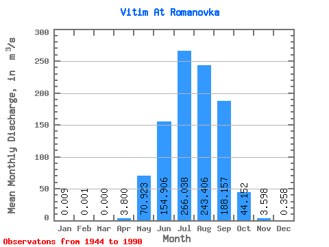
| Statistic | Jan | Feb | Mar | Apr | May | Jun | Jul | Aug | Sep | Oct | Nov | Dec | Annual |
|---|---|---|---|---|---|---|---|---|---|---|---|---|---|
| Mean | 0.01 | 0.00 | 0.00 | 3.80 | 70.92 | 154.91 | 266.04 | 243.41 | 188.16 | 44.15 | 3.60 | 0.36 | 81.28 |
| Standard Deviation | 0.02 | 0.00 | 0.00 | 7.34 | 54.68 | 170.09 | 233.63 | 212.16 | 164.91 | 34.83 | 2.40 | 0.46 | 46.57 |
| Min | 0.00 | 0.00 | 0.00 | 0.00 | 14.50 | 19.20 | 26.20 | 26.40 | 12.80 | 6.49 | 0.45 | 0.00 | 18.63 |
| Max | 0.11 | 0.03 | 0.00 | 35.60 | 335.00 | 1050.00 | 967.00 | 1020.00 | 765.00 | 172.00 | 10.10 | 2.31 | 187.14 |
| Coefficient of Variation | 2.15 | 6.86 | 1.93 | 0.77 | 1.10 | 0.88 | 0.87 | 0.88 | 0.79 | 0.67 | 1.28 | 0.57 |
 Return to R-Arctic Net Home Page