|
|
|||||||||||||||||
| Point ID: 6141 | Downloads | Plots | Site Data | Code: 3010 |
|
|
|||||||||||||||||
| Download | |
|---|---|
| Site Descriptor Information | Site Time Series Data |
| Link to all available data | |
| View: | Time Series | All |
| Units: | m3/s |
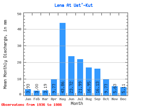
| Statistic | Jan | Feb | Mar | Apr | May | Jun | Jul | Aug | Sep | Oct | Nov | Dec | Annual |
|---|---|---|---|---|---|---|---|---|---|---|---|---|---|
| Mean | 3.93 | 3.03 | 3.19 | 9.77 | 43.85 | 23.72 | 21.98 | 16.95 | 16.13 | 9.77 | 5.63 | 5.10 | 156.93 |
| Standard Deviation | 1.40 | 1.12 | 1.26 | 8.04 | 13.20 | 12.67 | 13.28 | 9.41 | 8.04 | 3.81 | 2.26 | 1.92 | 40.64 |
| Min | 1.72 | 1.36 | 1.42 | 2.89 | 22.28 | 7.66 | 4.84 | 3.64 | 3.74 | 3.22 | 2.03 | 1.89 | 72.64 |
| Max | 6.41 | 5.09 | 5.59 | 25.16 | 67.14 | 45.38 | 55.51 | 42.76 | 36.67 | 14.37 | 8.79 | 8.06 | 220.94 |
| Coefficient of Variation | 0.36 | 0.37 | 0.40 | 0.82 | 0.30 | 0.53 | 0.60 | 0.56 | 0.50 | 0.39 | 0.40 | 0.38 | 0.26 |
 Return to R-Arctic Net Home Page