|
|
|||||||||||||||||
| Point ID: 6141 | Downloads | Plots | Site Data | Code: 3010 |
|
|
|||||||||||||||||
| Download | |
|---|---|
| Site Descriptor Information | Site Time Series Data |
| Link to all available data | |
| View: | Time Series | All |
| Units: | mm |
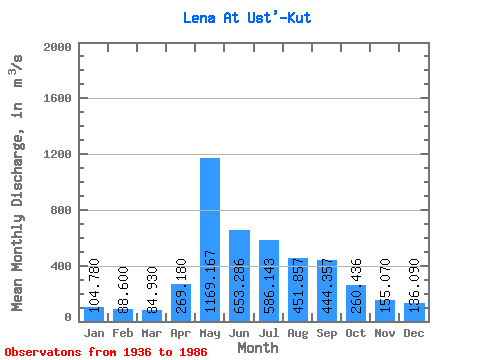
| Statistic | Jan | Feb | Mar | Apr | May | Jun | Jul | Aug | Sep | Oct | Nov | Dec | Annual |
|---|---|---|---|---|---|---|---|---|---|---|---|---|---|
| Mean | 104.78 | 88.60 | 84.93 | 269.18 | 1169.17 | 653.29 | 586.14 | 451.86 | 444.36 | 260.44 | 155.07 | 136.09 | 355.04 |
| Standard Deviation | 37.25 | 32.77 | 33.66 | 221.50 | 351.88 | 349.10 | 353.98 | 251.00 | 221.62 | 101.50 | 62.34 | 51.16 | 91.93 |
| Min | 45.80 | 39.70 | 37.80 | 79.60 | 594.00 | 211.00 | 129.00 | 97.00 | 103.00 | 85.80 | 56.00 | 50.50 | 164.33 |
| Max | 171.00 | 149.00 | 149.00 | 693.00 | 1790.00 | 1250.00 | 1480.00 | 1140.00 | 1010.00 | 383.00 | 242.00 | 215.00 | 499.83 |
| Coefficient of Variation | 0.36 | 0.37 | 0.40 | 0.82 | 0.30 | 0.53 | 0.60 | 0.56 | 0.50 | 0.39 | 0.40 | 0.38 | 0.26 |
 Return to R-Arctic Net Home Page