|
|
|||||||||||||||||
| Point ID: 5918 | Downloads | Plots | Site Data | Code: 1499 |
|
|
|||||||||||||||||
| Download | |
|---|---|
| Site Descriptor Information | Site Time Series Data |
| Link to all available data | |
| View: | Time Series | All |
| Units: | m3/s |
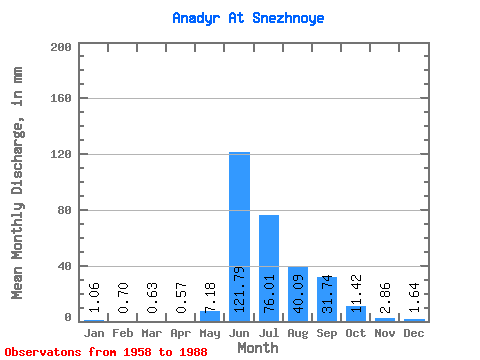
| Statistic | Jan | Feb | Mar | Apr | May | Jun | Jul | Aug | Sep | Oct | Nov | Dec | Annual |
|---|---|---|---|---|---|---|---|---|---|---|---|---|---|
| Mean | 1.06 | 0.71 | 0.63 | 0.57 | 7.18 | 121.79 | 76.00 | 40.09 | 31.74 | 11.42 | 2.86 | 1.64 | 295.58 |
| Standard Deviation | 0.35 | 0.25 | 0.20 | 0.18 | 10.44 | 22.82 | 35.31 | 11.80 | 14.65 | 6.32 | 1.13 | 0.52 | 50.75 |
| Min | 0.61 | 0.35 | 0.30 | 0.18 | 0.63 | 72.14 | 25.52 | 18.54 | 11.10 | 3.21 | 1.55 | 0.67 | 205.35 |
| Max | 1.89 | 1.32 | 1.06 | 0.99 | 54.57 | 164.57 | 156.38 | 61.14 | 68.47 | 29.56 | 6.80 | 2.93 | 402.74 |
| Coefficient of Variation | 0.33 | 0.35 | 0.31 | 0.32 | 1.45 | 0.19 | 0.47 | 0.29 | 0.46 | 0.55 | 0.40 | 0.32 | 0.17 |
 Return to R-Arctic Net Home Page