|
|
|||||||||||||||||
| Point ID: 5918 | Downloads | Plots | Site Data | Code: 1499 |
|
|
|||||||||||||||||
| Download | |
|---|---|
| Site Descriptor Information | Site Time Series Data |
| Link to all available data | |
| View: | Time Series | All |
| Units: | mm |
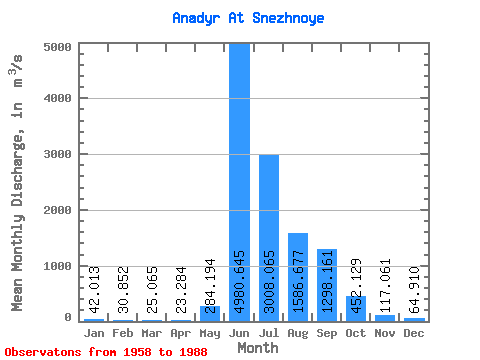
| Statistic | Jan | Feb | Mar | Apr | May | Jun | Jul | Aug | Sep | Oct | Nov | Dec | Annual |
|---|---|---|---|---|---|---|---|---|---|---|---|---|---|
| Mean | 42.01 | 30.85 | 25.07 | 23.28 | 284.19 | 4980.65 | 3008.07 | 1586.68 | 1298.16 | 452.13 | 117.06 | 64.91 | 992.75 |
| Standard Deviation | 14.00 | 10.76 | 7.78 | 7.49 | 413.28 | 933.30 | 1397.48 | 467.02 | 599.00 | 249.98 | 46.29 | 20.52 | 170.46 |
| Min | 24.10 | 15.40 | 11.90 | 7.50 | 25.00 | 2950.00 | 1010.00 | 734.00 | 454.00 | 127.00 | 63.30 | 26.50 | 689.71 |
| Max | 74.80 | 57.50 | 42.00 | 40.50 | 2160.00 | 6730.00 | 6190.00 | 2420.00 | 2800.00 | 1170.00 | 278.00 | 116.00 | 1352.68 |
| Coefficient of Variation | 0.33 | 0.35 | 0.31 | 0.32 | 1.45 | 0.19 | 0.47 | 0.29 | 0.46 | 0.55 | 0.40 | 0.32 | 0.17 |
 Return to R-Arctic Net Home Page