|
|
|||||||||||||||||
| Point ID: 5827 | Downloads | Plots | Site Data | Code: 09EB001 |
|
|
|||||||||||||||||
| Download | |
|---|---|
| Site Descriptor Information | Site Time Series Data |
| Link to all available data | |
| View: | Time Series | All |
| Units: | m3/s |
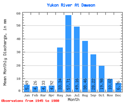
| Statistic | Jan | Feb | Mar | Apr | May | Jun | Jul | Aug | Sep | Oct | Nov | Dec | Annual |
|---|---|---|---|---|---|---|---|---|---|---|---|---|---|
| Mean | 5.49 | 4.29 | 4.33 | 4.92 | 33.34 | 57.71 | 49.15 | 38.46 | 28.22 | 19.98 | 10.02 | 6.76 | 263.70 |
| Standard Deviation | 1.34 | 0.94 | 0.86 | 1.36 | 8.90 | 16.64 | 9.74 | 6.23 | 3.98 | 4.39 | 2.42 | 1.78 | 39.41 |
| Min | 2.31 | 1.71 | 2.30 | 2.62 | 16.94 | 38.78 | 32.87 | 28.71 | 21.01 | 11.36 | 5.38 | 3.34 | 192.19 |
| Max | 9.19 | 6.04 | 5.74 | 8.87 | 49.10 | 119.78 | 72.43 | 51.43 | 34.66 | 31.34 | 15.02 | 11.87 | 354.34 |
| Coefficient of Variation | 0.24 | 0.22 | 0.20 | 0.28 | 0.27 | 0.29 | 0.20 | 0.16 | 0.14 | 0.22 | 0.24 | 0.26 | 0.15 |
 Return to R-Arctic Net Home Page