|
|
|||||||||||||||||
| Point ID: 5827 | Downloads | Plots | Site Data | Code: 09EB001 |
|
|
|||||||||||||||||
| Download | |
|---|---|
| Site Descriptor Information | Site Time Series Data |
| Link to all available data | |
| View: | Time Series | All |
| Units: | mm |
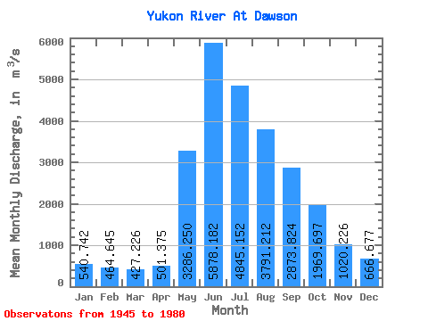
| Statistic | Jan | Feb | Mar | Apr | May | Jun | Jul | Aug | Sep | Oct | Nov | Dec | Annual |
|---|---|---|---|---|---|---|---|---|---|---|---|---|---|
| Mean | 540.74 | 464.64 | 427.23 | 501.38 | 3286.25 | 5878.18 | 4845.15 | 3791.21 | 2873.82 | 1969.70 | 1020.23 | 666.68 | 2205.85 |
| Standard Deviation | 132.16 | 101.33 | 84.73 | 138.91 | 877.52 | 1694.76 | 960.69 | 614.07 | 405.37 | 432.60 | 246.25 | 175.53 | 329.68 |
| Min | 228.00 | 185.00 | 227.00 | 267.00 | 1670.00 | 3950.00 | 3240.00 | 2830.00 | 2140.00 | 1120.00 | 548.00 | 329.00 | 1607.67 |
| Max | 906.00 | 654.00 | 566.00 | 903.00 | 4840.00 | 12200.00 | 7140.00 | 5070.00 | 3530.00 | 3090.00 | 1530.00 | 1170.00 | 2964.08 |
| Coefficient of Variation | 0.24 | 0.22 | 0.20 | 0.28 | 0.27 | 0.29 | 0.20 | 0.16 | 0.14 | 0.22 | 0.24 | 0.26 | 0.15 |
 Return to R-Arctic Net Home Page