|
|
|||||||||||||||||
| Point ID: 5822 | Downloads | Plots | Site Data | Other Close Sites | Code: 09DD003 |
|
|
|||||||||||||||||
| Download | |
|---|---|
| Site Descriptor Information | Site Time Series Data |
| Link to all available data | |
| View: | Time Series | All |
| Units: | m3/s |
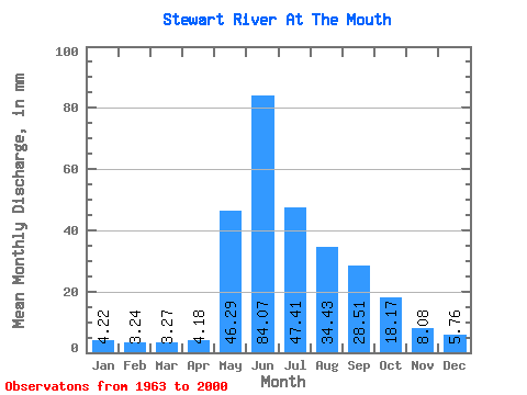
| Statistic | Jan | Feb | Mar | Apr | May | Jun | Jul | Aug | Sep | Oct | Nov | Dec | Annual |
|---|---|---|---|---|---|---|---|---|---|---|---|---|---|
| Mean | 4.22 | 3.26 | 3.27 | 4.18 | 46.28 | 84.07 | 47.41 | 34.42 | 28.51 | 18.16 | 8.09 | 5.76 | 286.66 |
| Standard Deviation | 0.76 | 0.57 | 0.62 | 1.34 | 14.95 | 29.16 | 14.11 | 10.41 | 9.39 | 5.36 | 1.97 | 1.24 | 54.67 |
| Min | 2.77 | 1.90 | 1.89 | 2.15 | 11.55 | 46.71 | 25.78 | 15.96 | 11.89 | 8.40 | 4.01 | 3.72 | 206.13 |
| Max | 6.72 | 5.07 | 4.74 | 7.72 | 82.44 | 200.25 | 88.74 | 63.01 | 53.37 | 31.19 | 13.37 | 9.24 | 454.86 |
| Coefficient of Variation | 0.18 | 0.18 | 0.19 | 0.32 | 0.32 | 0.35 | 0.30 | 0.30 | 0.33 | 0.29 | 0.24 | 0.21 | 0.19 |
| Other Close Sites | ||||||
|---|---|---|---|---|---|---|
| PointID | Latitude | Longitude | Drainage Area | Source | Name | |
| 5828 | "YUKON RIVER AT STEWART RIVER" | 63.31 | 2233789 | Hydat | ||
 Return to R-Arctic Net Home Page