|
|
|||||||||||||||||
| Point ID: 5816 | Downloads | Plots | Site Data | Code: 09CD001 |
|
|
|||||||||||||||||
| Download | |
|---|---|
| Site Descriptor Information | Site Time Series Data |
| Link to all available data | |
| View: | Time Series | All |
| Units: | m3/s |
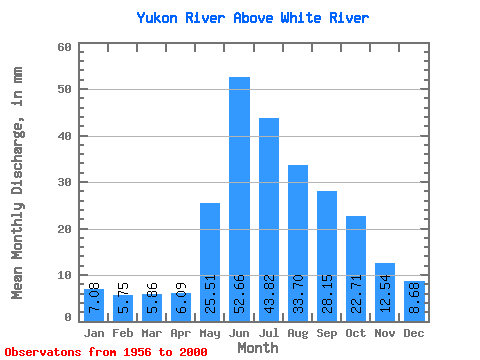
| Statistic | Jan | Feb | Mar | Apr | May | Jun | Jul | Aug | Sep | Oct | Nov | Dec | Annual |
|---|---|---|---|---|---|---|---|---|---|---|---|---|---|
| Mean | 7.08 | 5.80 | 5.86 | 6.09 | 25.50 | 52.66 | 43.81 | 33.70 | 28.16 | 22.70 | 12.54 | 8.68 | 248.00 |
| Standard Deviation | 1.23 | 0.95 | 0.90 | 1.08 | 6.30 | 15.80 | 10.70 | 6.42 | 6.33 | 5.55 | 3.04 | 1.82 | 37.36 |
| Min | 4.89 | 3.97 | 4.23 | 4.09 | 12.37 | 30.76 | 24.10 | 19.46 | 16.24 | 13.46 | 7.93 | 5.68 | 166.87 |
| Max | 10.62 | 7.82 | 7.59 | 9.31 | 40.53 | 105.06 | 73.20 | 48.38 | 50.80 | 43.56 | 23.33 | 16.10 | 336.96 |
| Coefficient of Variation | 0.17 | 0.16 | 0.15 | 0.18 | 0.25 | 0.30 | 0.24 | 0.19 | 0.23 | 0.24 | 0.24 | 0.21 | 0.15 |
 Return to R-Arctic Net Home Page