|
|
|||||||||||||||||
| Point ID: 5816 | Downloads | Plots | Site Data | Code: 09CD001 |
|
|
|||||||||||||||||
| Download | |
|---|---|
| Site Descriptor Information | Site Time Series Data |
| Link to all available data | |
| View: | Time Series | All |
| Units: | mm |
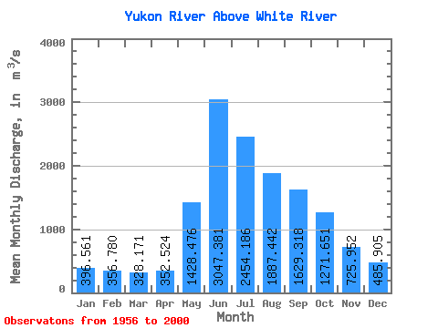
| Statistic | Jan | Feb | Mar | Apr | May | Jun | Jul | Aug | Sep | Oct | Nov | Dec | Annual |
|---|---|---|---|---|---|---|---|---|---|---|---|---|---|
| Mean | 396.56 | 356.78 | 328.17 | 352.52 | 1428.48 | 3047.38 | 2454.19 | 1887.44 | 1629.32 | 1271.65 | 725.95 | 485.90 | 1178.69 |
| Standard Deviation | 68.73 | 58.45 | 50.19 | 62.77 | 352.85 | 914.30 | 599.37 | 359.83 | 366.20 | 310.76 | 176.20 | 101.90 | 177.59 |
| Min | 274.00 | 244.00 | 237.00 | 237.00 | 693.00 | 1780.00 | 1350.00 | 1090.00 | 940.00 | 754.00 | 459.00 | 318.00 | 793.08 |
| Max | 595.00 | 481.00 | 425.00 | 539.00 | 2270.00 | 6080.00 | 4100.00 | 2710.00 | 2940.00 | 2440.00 | 1350.00 | 902.00 | 1601.50 |
| Coefficient of Variation | 0.17 | 0.16 | 0.15 | 0.18 | 0.25 | 0.30 | 0.24 | 0.19 | 0.23 | 0.24 | 0.24 | 0.21 | 0.15 |
 Return to R-Arctic Net Home Page