|
|
|||||||||||||||||
| Point ID: 5807 | Downloads | Plots | Site Data | Code: 09BC002 |
|
|
|||||||||||||||||
| Download | |
|---|---|
| Site Descriptor Information | Site Time Series Data |
| Link to all available data | |
| View: | Time Series | All |
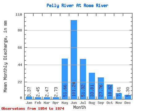
| Units: | m3/s |
| Statistic | Jan | Feb | Mar | Apr | May | Jun | Jul | Aug | Sep | Oct | Nov | Dec | Annual |
|---|---|---|---|---|---|---|---|---|---|---|---|---|---|
| Mean | 3.37 | 2.47 | 2.47 | 2.73 | 51.65 | 101.24 | 51.31 | 33.81 | 27.76 | 18.81 | 7.81 | 5.30 | 319.96 |
| Standard Deviation | 1.20 | 0.76 | 0.68 | 0.53 | 15.14 | 32.78 | 13.12 | 11.23 | 9.87 | 5.54 | 2.17 | 1.78 | 51.55 |
| Min | 1.29 | 0.92 | 0.94 | 1.54 | 16.01 | 50.43 | 25.76 | 19.07 | 8.35 | 8.88 | 5.21 | 2.42 | 250.84 |
| Max | 5.69 | 4.06 | 3.51 | 3.51 | 72.77 | 185.95 | 79.03 | 60.69 | 48.18 | 26.93 | 11.88 | 8.79 | 424.35 |
| Coefficient of Variation | 0.36 | 0.31 | 0.28 | 0.19 | 0.29 | 0.32 | 0.26 | 0.33 | 0.36 | 0.29 | 0.28 | 0.34 | 0.16 |
 Return to R-Arctic Net Home Page