|
|
|||||||||||||||||
| Point ID: 5807 | Downloads | Plots | Site Data | Code: 09BC002 |
|
|
|||||||||||||||||
| Download | |
|---|---|
| Site Descriptor Information | Site Time Series Data |
| Link to all available data | |
| View: | Time Series | All |
| Units: | mm |
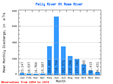
| Statistic | Jan | Feb | Mar | Apr | May | Jun | Jul | Aug | Sep | Oct | Nov | Dec | Annual |
|---|---|---|---|---|---|---|---|---|---|---|---|---|---|
| Mean | 23.15 | 18.60 | 16.97 | 19.39 | 354.89 | 718.70 | 352.57 | 232.29 | 197.06 | 129.26 | 55.41 | 36.43 | 186.54 |
| Standard Deviation | 8.27 | 5.76 | 4.68 | 3.73 | 104.06 | 232.67 | 90.13 | 77.20 | 70.07 | 38.05 | 15.40 | 12.25 | 30.05 |
| Min | 8.86 | 6.95 | 6.45 | 10.90 | 110.00 | 358.00 | 177.00 | 131.00 | 59.30 | 61.00 | 37.00 | 16.60 | 146.25 |
| Max | 39.10 | 30.60 | 24.10 | 24.90 | 500.00 | 1320.00 | 543.00 | 417.00 | 342.00 | 185.00 | 84.30 | 60.40 | 247.40 |
| Coefficient of Variation | 0.36 | 0.31 | 0.28 | 0.19 | 0.29 | 0.32 | 0.26 | 0.33 | 0.36 | 0.29 | 0.28 | 0.34 | 0.16 |
 Return to R-Arctic Net Home Page