|
|
|||||||||||||||||
| Point ID: 5799 | Downloads | Plots | Site Data | Code: 09AH001 |
|
|
|||||||||||||||||
| Download | |
|---|---|
| Site Descriptor Information | Site Time Series Data |
| Link to all available data | |
| View: | Time Series | All |
| Units: | m3/s |
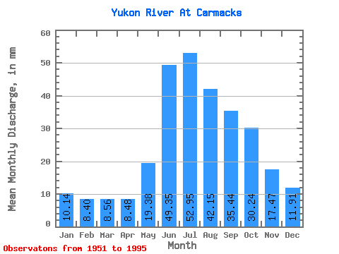
| Statistic | Jan | Feb | Mar | Apr | May | Jun | Jul | Aug | Sep | Oct | Nov | Dec | Annual |
|---|---|---|---|---|---|---|---|---|---|---|---|---|---|
| Mean | 10.13 | 8.47 | 8.56 | 8.48 | 19.38 | 49.35 | 52.94 | 42.14 | 35.44 | 30.23 | 17.47 | 11.91 | 290.88 |
| Standard Deviation | 2.20 | 1.70 | 1.67 | 1.93 | 4.75 | 12.25 | 12.41 | 6.97 | 5.90 | 6.55 | 4.81 | 2.98 | 39.24 |
| Min | 5.30 | 4.36 | 4.52 | 4.50 | 11.56 | 28.49 | 29.96 | 27.96 | 25.03 | 18.89 | 10.14 | 5.99 | 202.56 |
| Max | 15.94 | 13.15 | 13.13 | 13.34 | 31.59 | 77.00 | 88.07 | 55.33 | 50.07 | 44.85 | 28.80 | 20.40 | 371.99 |
| Coefficient of Variation | 0.22 | 0.20 | 0.20 | 0.23 | 0.24 | 0.25 | 0.23 | 0.17 | 0.17 | 0.22 | 0.28 | 0.25 | 0.14 |
 Return to R-Arctic Net Home Page