|
|
|||||||||||||||||
| Point ID: 5799 | Downloads | Plots | Site Data | Code: 09AH001 |
|
|
|||||||||||||||||
| Download | |
|---|---|
| Site Descriptor Information | Site Time Series Data |
| Link to all available data | |
| View: | Time Series | All |
| Units: | mm |
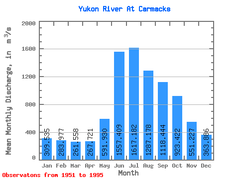
| Statistic | Jan | Feb | Mar | Apr | May | Jun | Jul | Aug | Sep | Oct | Nov | Dec | Annual |
|---|---|---|---|---|---|---|---|---|---|---|---|---|---|
| Mean | 309.54 | 283.98 | 261.56 | 267.72 | 591.93 | 1557.41 | 1617.18 | 1287.18 | 1118.44 | 923.42 | 551.23 | 363.89 | 753.94 |
| Standard Deviation | 67.21 | 56.97 | 51.13 | 60.92 | 145.08 | 386.70 | 378.96 | 212.90 | 186.27 | 199.96 | 151.92 | 90.93 | 101.69 |
| Min | 162.00 | 146.00 | 138.00 | 142.00 | 353.00 | 899.00 | 915.00 | 854.00 | 790.00 | 577.00 | 320.00 | 183.00 | 525.00 |
| Max | 487.00 | 441.00 | 401.00 | 421.00 | 965.00 | 2430.00 | 2690.00 | 1690.00 | 1580.00 | 1370.00 | 909.00 | 623.00 | 964.17 |
| Coefficient of Variation | 0.22 | 0.20 | 0.20 | 0.23 | 0.24 | 0.25 | 0.23 | 0.17 | 0.17 | 0.22 | 0.28 | 0.25 | 0.14 |
 Return to R-Arctic Net Home Page