|
|
|||||||||||||||||
| Point ID: 5789 | Downloads | Plots | Site Data | Code: 09AB009 |
|
|
|||||||||||||||||
| Download | |
|---|---|
| Site Descriptor Information | Site Time Series Data |
| Link to all available data | |
| View: | Time Series | All |
| Units: | m3/s |
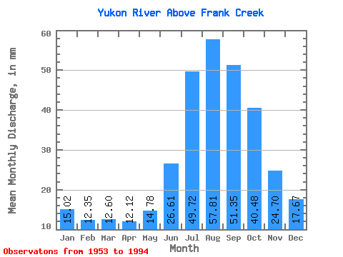
| Statistic | Jan | Feb | Mar | Apr | May | Jun | Jul | Aug | Sep | Oct | Nov | Dec | Annual |
|---|---|---|---|---|---|---|---|---|---|---|---|---|---|
| Mean | 15.02 | 12.45 | 12.60 | 12.12 | 14.78 | 26.61 | 49.72 | 57.80 | 51.35 | 40.47 | 24.70 | 17.66 | 334.36 |
| Standard Deviation | 2.95 | 2.51 | 2.70 | 2.95 | 3.10 | 6.92 | 9.12 | 6.81 | 6.85 | 8.46 | 5.77 | 3.61 | 38.63 |
| Min | 8.15 | 6.66 | 6.50 | 6.24 | 9.56 | 17.42 | 31.82 | 40.69 | 36.52 | 24.43 | 15.82 | 10.78 | 259.58 |
| Max | 20.69 | 17.43 | 16.61 | 18.09 | 20.61 | 51.59 | 66.52 | 70.08 | 63.71 | 57.04 | 36.35 | 26.26 | 405.86 |
| Coefficient of Variation | 0.20 | 0.20 | 0.21 | 0.24 | 0.21 | 0.26 | 0.18 | 0.12 | 0.13 | 0.21 | 0.23 | 0.20 | 0.12 |
 Return to R-Arctic Net Home Page