|
|
|||||||||||||||||
| Point ID: 5789 | Downloads | Plots | Site Data | Code: 09AB009 |
|
|
|||||||||||||||||
| Download | |
|---|---|
| Site Descriptor Information | Site Time Series Data |
| Link to all available data | |
| View: | Time Series | All |
| Units: | mm |
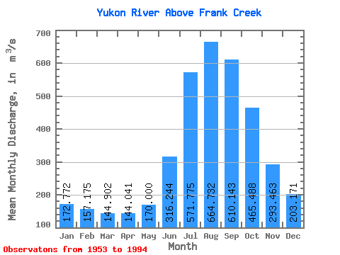
| Statistic | Jan | Feb | Mar | Apr | May | Jun | Jul | Aug | Sep | Oct | Nov | Dec | Annual |
|---|---|---|---|---|---|---|---|---|---|---|---|---|---|
| Mean | 172.77 | 157.18 | 144.90 | 144.04 | 170.00 | 316.24 | 571.77 | 664.73 | 610.14 | 465.49 | 293.46 | 203.17 | 326.31 |
| Standard Deviation | 33.95 | 31.66 | 31.05 | 35.03 | 35.63 | 82.22 | 104.91 | 78.35 | 81.38 | 97.27 | 68.61 | 41.48 | 37.70 |
| Min | 93.70 | 84.00 | 74.70 | 74.10 | 110.00 | 207.00 | 366.00 | 468.00 | 434.00 | 281.00 | 188.00 | 124.00 | 253.33 |
| Max | 238.00 | 220.00 | 191.00 | 215.00 | 237.00 | 613.00 | 765.00 | 806.00 | 757.00 | 656.00 | 432.00 | 302.00 | 396.08 |
| Coefficient of Variation | 0.20 | 0.20 | 0.21 | 0.24 | 0.21 | 0.26 | 0.18 | 0.12 | 0.13 | 0.21 | 0.23 | 0.20 | 0.12 |
 Return to R-Arctic Net Home Page