|
|
|||||||||||||||||
| Point ID: 5597 | Downloads | Plots | Site Data | Other Close Sites | Code: 06DB002 |
|
|
|||||||||||||||||
| Download | |
|---|---|
| Site Descriptor Information | Site Time Series Data |
| Link to all available data | |
| View: | Time Series | All |
| Units: | m3/s |
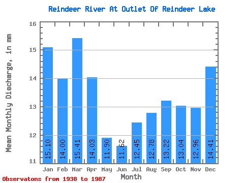
| Statistic | Jan | Feb | Mar | Apr | May | Jun | Jul | Aug | Sep | Oct | Nov | Dec | Annual |
|---|---|---|---|---|---|---|---|---|---|---|---|---|---|
| Mean | 15.10 | 14.12 | 15.41 | 14.03 | 11.90 | 11.62 | 12.45 | 12.78 | 13.22 | 13.04 | 12.96 | 14.41 | 161.45 |
| Standard Deviation | 4.06 | 3.97 | 4.16 | 3.87 | 3.94 | 5.92 | 8.50 | 7.87 | 6.73 | 4.63 | 3.51 | 3.78 | 36.99 |
| Min | 6.50 | 1.17 | 1.35 | 1.36 | 1.54 | 0.00 | 0.00 | 0.00 | 0.00 | 1.05 | 2.62 | 6.08 | 78.29 |
| Max | 23.02 | 21.48 | 22.33 | 20.87 | 19.68 | 30.02 | 36.75 | 36.28 | 34.99 | 26.82 | 20.91 | 22.55 | 276.65 |
| Coefficient of Variation | 0.27 | 0.28 | 0.27 | 0.28 | 0.33 | 0.51 | 0.68 | 0.62 | 0.51 | 0.35 | 0.27 | 0.26 | 0.23 |
| Other Close Sites | ||||||
|---|---|---|---|---|---|---|
| PointID | Latitude | Longitude | Drainage Area | Source | Name | |
| 5601 | "REINDEER RIVER ABOVE DEVIL RAPIDS" | 56.19 | 842966 | Hydat | ||
 Return to R-Arctic Net Home Page