|
|
|||||||||||||||||
| Point ID: 5597 | Downloads | Plots | Site Data | Other Close Sites | Code: 06DB002 |
|
|
|||||||||||||||||
| Download | |
|---|---|
| Site Descriptor Information | Site Time Series Data |
| Link to all available data | |
| View: | Time Series | All |
| Units: | mm |
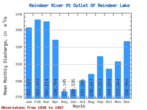
| Statistic | Jan | Feb | Mar | Apr | May | Jun | Jul | Aug | Sep | Oct | Nov | Dec | Annual |
|---|---|---|---|---|---|---|---|---|---|---|---|---|---|
| Mean | 353.02 | 362.14 | 360.21 | 338.79 | 278.14 | 280.54 | 291.05 | 298.65 | 319.25 | 304.69 | 313.06 | 336.90 | 320.24 |
| Standard Deviation | 94.98 | 101.89 | 97.24 | 93.39 | 92.22 | 143.02 | 198.78 | 184.06 | 162.54 | 108.25 | 84.82 | 88.44 | 73.37 |
| Min | 152.00 | 30.00 | 31.50 | 32.90 | 36.10 | 0.00 | 0.00 | 0.00 | 0.00 | 24.60 | 63.20 | 142.00 | 155.29 |
| Max | 538.00 | 551.00 | 522.00 | 504.00 | 460.00 | 725.00 | 859.00 | 848.00 | 845.00 | 627.00 | 505.00 | 527.00 | 548.75 |
| Coefficient of Variation | 0.27 | 0.28 | 0.27 | 0.28 | 0.33 | 0.51 | 0.68 | 0.62 | 0.51 | 0.35 | 0.27 | 0.26 | 0.23 |
| Other Close Sites | ||||||
|---|---|---|---|---|---|---|
| PointID | Latitude | Longitude | Drainage Area | Source | Name | |
| 5601 | "REINDEER RIVER ABOVE DEVIL RAPIDS" | 56.19 | 842966 | Hydat | ||
 Return to R-Arctic Net Home Page