|
|
|||||||||||||||||
| Point ID: 5441 | Downloads | Plots | Site Data | Other Close Sites | Code: 05KD003 |
|
|
|||||||||||||||||
| Download | |
|---|---|
| Site Descriptor Information | Site Time Series Data |
| Link to all available data | |
| View: | Time Series | All |
| Units: | m3/s |
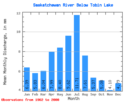
| Statistic | Jan | Feb | Mar | Apr | May | Jun | Jul | Aug | Sep | Oct | Nov | Dec | Annual |
|---|---|---|---|---|---|---|---|---|---|---|---|---|---|
| Mean | 3.72 | 3.42 | 3.51 | 4.64 | 4.88 | 5.59 | 6.81 | 4.42 | 3.12 | 2.96 | 2.38 | 2.78 | 48.38 |
| Standard Deviation | 1.05 | 1.05 | 1.10 | 1.44 | 2.31 | 2.93 | 3.78 | 2.04 | 1.04 | 1.15 | 0.70 | 0.80 | 11.23 |
| Min | 0.66 | 0.60 | 0.77 | 2.28 | 1.81 | 1.58 | 2.17 | 1.45 | 1.60 | 0.19 | 0.95 | 0.63 | 27.75 |
| Max | 4.96 | 4.82 | 5.36 | 9.51 | 13.99 | 14.53 | 19.64 | 9.54 | 5.79 | 6.35 | 4.17 | 3.99 | 76.41 |
| Coefficient of Variation | 0.28 | 0.31 | 0.31 | 0.31 | 0.47 | 0.52 | 0.56 | 0.46 | 0.33 | 0.39 | 0.29 | 0.29 | 0.23 |
| Other Close Sites | ||||||
|---|---|---|---|---|---|---|
| PointID | Latitude | Longitude | Drainage Area | Source | Name | |
| 5442 | "SASKATCHEWAN RIVER ABOVE SIPANOK CHANNEL" | 53.71 | 910208 | Hydat | ||
 Return to R-Arctic Net Home Page