|
|
|||||||||||||||||
| Point ID: 5441 | Downloads | Plots | Site Data | Other Close Sites | Code: 05KD003 |
|
|
|||||||||||||||||
| Download | |
|---|---|
| Site Descriptor Information | Site Time Series Data |
| Link to all available data | |
| View: | Time Series | All |
| Units: | mm |
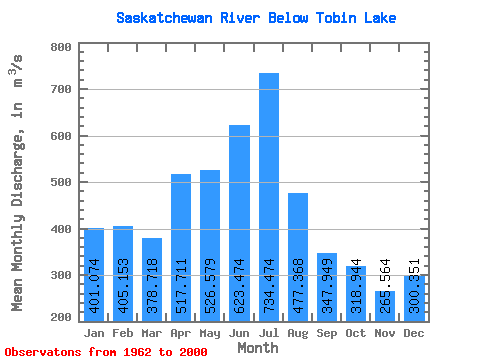
| Statistic | Jan | Feb | Mar | Apr | May | Jun | Jul | Aug | Sep | Oct | Nov | Dec | Annual |
|---|---|---|---|---|---|---|---|---|---|---|---|---|---|
| Mean | 401.07 | 405.15 | 378.72 | 517.71 | 526.58 | 623.47 | 734.47 | 477.37 | 347.95 | 318.94 | 265.56 | 300.35 | 443.00 |
| Standard Deviation | 113.03 | 124.29 | 118.95 | 160.78 | 249.17 | 326.56 | 407.66 | 220.21 | 115.65 | 124.08 | 77.90 | 86.26 | 102.80 |
| Min | 70.80 | 70.80 | 83.30 | 254.00 | 195.00 | 176.00 | 234.00 | 156.00 | 178.00 | 20.80 | 106.00 | 67.80 | 254.08 |
| Max | 535.00 | 571.00 | 578.00 | 1060.00 | 1510.00 | 1620.00 | 2120.00 | 1030.00 | 645.00 | 685.00 | 465.00 | 431.00 | 699.67 |
| Coefficient of Variation | 0.28 | 0.31 | 0.31 | 0.31 | 0.47 | 0.52 | 0.56 | 0.46 | 0.33 | 0.39 | 0.29 | 0.29 | 0.23 |
| Other Close Sites | ||||||
|---|---|---|---|---|---|---|
| PointID | Latitude | Longitude | Drainage Area | Source | Name | |
| 5442 | "SASKATCHEWAN RIVER ABOVE SIPANOK CHANNEL" | 53.71 | 910208 | Hydat | ||
 Return to R-Arctic Net Home Page