|
|
|||||||||||||||||
| Point ID: 5241 | Downloads | Plots | Site Data | Code: 05HA016 |
|
|
|||||||||||||||||
| Download | |
|---|---|
| Site Descriptor Information | Site Time Series Data |
| Link to all available data | |
| View: | Time Series | All |
| Units: | m3/s |
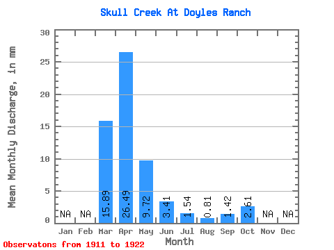
| Statistic | Jan | Feb | Mar | Apr | May | Jun | Jul | Aug | Sep | Oct | Nov | Dec | Annual |
|---|---|---|---|---|---|---|---|---|---|---|---|---|---|
| Mean | 14.13 | 23.54 | 8.65 | 3.04 | 1.36 | 0.72 | 1.25 | 2.32 | |||||
| Standard Deviation | 12.33 | 19.57 | 10.13 | 2.10 | 1.23 | 0.66 | 0.77 | 1.15 | |||||
| Min | 2.67 | 6.63 | 2.61 | 0.60 | 0.13 | 0.00 | 0.13 | 0.85 | |||||
| Max | 33.60 | 70.10 | 39.80 | 6.95 | 4.54 | 1.86 | 2.87 | 4.34 | |||||
| Coefficient of Variation | 0.87 | 0.83 | 1.17 | 0.69 | 0.91 | 0.92 | 0.62 | 0.50 |
 Return to R-Arctic Net Home Page