|
|
|||||||||||||||||
| Point ID: 5241 | Downloads | Plots | Site Data | Code: 05HA016 |
|
|
|||||||||||||||||
| Download | |
|---|---|
| Site Descriptor Information | Site Time Series Data |
| Link to all available data | |
|
|
| View: | Statistics | Time Series |
| Units: | m3/s |
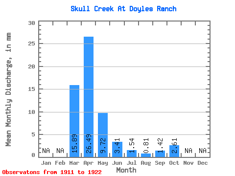
| Statistic | Jan | Feb | Mar | Apr | May | Jun | Jul | Aug | Sep | Oct | Nov | Dec | Annual |
|---|---|---|---|---|---|---|---|---|---|---|---|---|---|
| Mean | 14.13 | 23.54 | 8.65 | 3.04 | 1.36 | 0.72 | 1.25 | 2.32 | |||||
| Standard Deviation | 12.33 | 19.57 | 10.13 | 2.10 | 1.23 | 0.66 | 0.77 | 1.15 | |||||
| Min | 2.67 | 6.63 | 2.61 | 0.60 | 0.13 | 0.00 | 0.13 | 0.85 | |||||
| Max | 33.60 | 70.10 | 39.80 | 6.95 | 4.54 | 1.86 | 2.87 | 4.34 | |||||
| Coefficient of Variation | 0.87 | 0.83 | 1.17 | 0.69 | 0.91 | 0.92 | 0.62 | 0.50 |
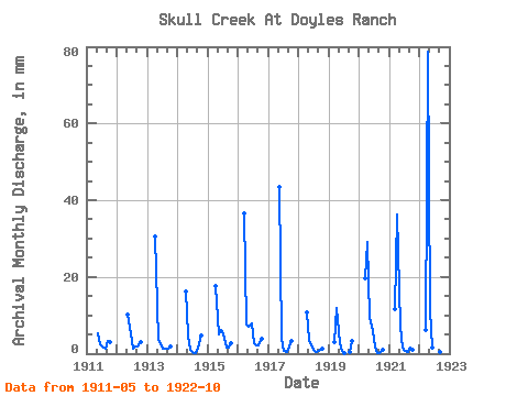
| Year | Jan | Feb | Mar | Apr | May | Jun | Jul | Aug | Sep | Oct | Nov | Dec | Annual | 1911 | 4.93 | 2.05 | 1.76 | 1.11 | 2.87 | 2.81 | 1912 | 9.39 | 4.71 | 1.30 | 1.60 | 1.55 | 2.81 | 1913 | 27.19 | 3.23 | 2.18 | 1.27 | 1.11 | 1.17 | 1.73 | 1914 | 14.34 | 4.27 | 0.88 | 0.13 | 0.16 | 1.36 | 4.34 | 1915 | 15.57 | 4.70 | 5.56 | 4.54 | 1.44 | 1.42 | 2.45 | 1916 | 33.60 | 6.63 | 6.39 | 6.95 | 2.58 | 1.86 | 1.93 | 3.65 | 1917 | 39.80 | 3.54 | 0.78 | 0.46 | 1.67 | 3.00 | 1918 | 9.47 | 3.26 | 1.80 | 0.56 | 0.49 | 0.60 | 1.14 | 1919 | 2.67 | 10.52 | 2.61 | 0.60 | 0.13 | 0.00 | 0.51 | 3.07 | 1920 | 17.94 | 25.86 | 8.48 | 5.27 | 1.83 | 0.03 | 0.13 | 1.01 | 1921 | 10.80 | 32.21 | 6.36 | 1.39 | 0.65 | 0.29 | 1.42 | 1.04 | 1922 | 5.61 | 70.10 | 10.41 | 1.52 | 0.78 | 0.13 | 0.35 | 0.85 |
|---|
 Return to R-Arctic Net Home Page