|
|
|||||||||||||||||
| Point ID: 3604 | Downloads | Plots | Site Data | Code: 10ED001 |
|
|
|||||||||||||||||
| Download | |
|---|---|
| Site Descriptor Information | Site Time Series Data |
| Link to all available data | |
| View: | Time Series | All |
| Units: | m3/s |
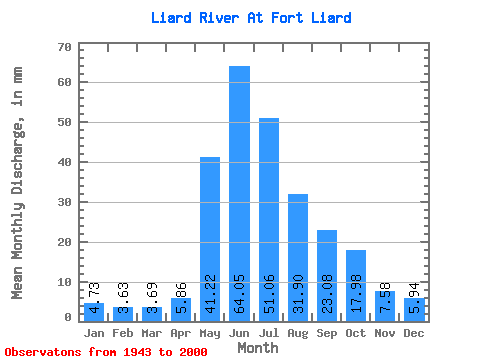
| Statistic | Jan | Feb | Mar | Apr | May | Jun | Jul | Aug | Sep | Oct | Nov | Dec | Annual |
|---|---|---|---|---|---|---|---|---|---|---|---|---|---|
| Mean | 4.73 | 3.66 | 3.69 | 5.86 | 41.21 | 64.05 | 51.05 | 31.89 | 23.08 | 17.98 | 7.58 | 5.94 | 272.86 |
| Standard Deviation | 1.01 | 0.78 | 0.71 | 2.09 | 11.83 | 15.81 | 16.38 | 9.87 | 6.97 | 4.88 | 2.21 | 1.53 | 43.15 |
| Min | 2.47 | 2.00 | 2.21 | 3.06 | 22.68 | 34.79 | 25.82 | 16.53 | 11.56 | 7.33 | 4.48 | 3.39 | 184.00 |
| Max | 7.47 | 5.75 | 5.50 | 10.26 | 71.29 | 105.78 | 99.76 | 65.98 | 40.87 | 33.66 | 13.54 | 9.49 | 382.05 |
| Coefficient of Variation | 0.21 | 0.21 | 0.19 | 0.36 | 0.29 | 0.25 | 0.32 | 0.31 | 0.30 | 0.27 | 0.29 | 0.26 | 0.16 |
 Return to R-Arctic Net Home Page