|
|
|||||||||||||||||
| Point ID: 3604 | Downloads | Plots | Site Data | Code: 10ED001 |
|
|
|||||||||||||||||
| Download | |
|---|---|
| Site Descriptor Information | Site Time Series Data |
| Link to all available data | |
| View: | Time Series | All |
| Units: | mm |
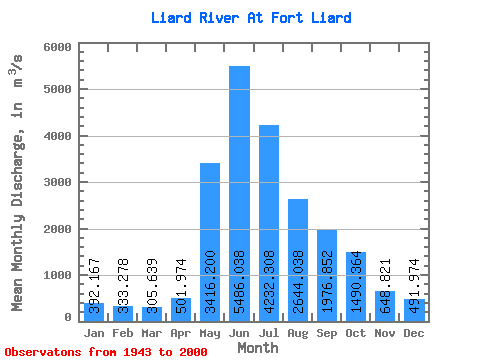
| Statistic | Jan | Feb | Mar | Apr | May | Jun | Jul | Aug | Sep | Oct | Nov | Dec | Annual |
|---|---|---|---|---|---|---|---|---|---|---|---|---|---|
| Mean | 392.17 | 333.28 | 305.64 | 501.97 | 3416.20 | 5486.04 | 4232.31 | 2644.04 | 1976.85 | 1490.36 | 648.82 | 491.97 | 1919.38 |
| Standard Deviation | 83.49 | 71.11 | 58.89 | 178.93 | 980.94 | 1353.75 | 1358.19 | 818.23 | 597.41 | 404.99 | 189.49 | 126.54 | 303.55 |
| Min | 205.00 | 182.00 | 183.00 | 262.00 | 1880.00 | 2980.00 | 2140.00 | 1370.00 | 990.00 | 608.00 | 384.00 | 281.00 | 1294.33 |
| Max | 619.00 | 523.00 | 456.00 | 879.00 | 5910.00 | 9060.00 | 8270.00 | 5470.00 | 3500.00 | 2790.00 | 1160.00 | 787.00 | 2687.42 |
| Coefficient of Variation | 0.21 | 0.21 | 0.19 | 0.36 | 0.29 | 0.25 | 0.32 | 0.31 | 0.30 | 0.27 | 0.29 | 0.26 | 0.16 |
 Return to R-Arctic Net Home Page