|
|
|||||||||||||||||
| Point ID: 3546 | Downloads | Plots | Site Data | Code: 06OA001 |
|
|
|||||||||||||||||
| Download | |
|---|---|
| Site Descriptor Information | Site Time Series Data |
| Link to all available data | |
| View: | Time Series | All |
| Units: | m3/s |
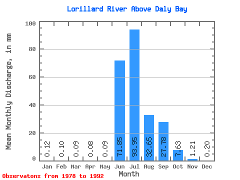
| Statistic | Jan | Feb | Mar | Apr | May | Jun | Jul | Aug | Sep | Oct | Nov | Dec | Annual |
|---|---|---|---|---|---|---|---|---|---|---|---|---|---|
| Mean | 0.12 | 0.10 | 0.09 | 0.08 | 0.09 | 71.85 | 93.93 | 32.65 | 27.78 | 7.63 | 1.21 | 0.20 | 235.16 |
| Standard Deviation | 0.15 | 0.13 | 0.14 | 0.13 | 0.13 | 55.24 | 51.72 | 26.34 | 21.65 | 3.84 | 0.96 | 0.22 | 71.88 |
| Min | 0.00 | 0.00 | 0.00 | 0.00 | 0.00 | 0.53 | 29.21 | 11.78 | 5.58 | 2.77 | 0.16 | 0.00 | 135.44 |
| Max | 0.36 | 0.33 | 0.36 | 0.35 | 0.36 | 181.91 | 204.99 | 91.30 | 83.65 | 14.22 | 3.18 | 0.55 | 362.15 |
| Coefficient of Variation | 1.20 | 1.25 | 1.49 | 1.60 | 1.53 | 0.77 | 0.55 | 0.81 | 0.78 | 0.50 | 0.80 | 1.11 | 0.31 |
 Return to R-Arctic Net Home Page