|
|
|||||||||||||||||
| Point ID: 3546 | Downloads | Plots | Site Data | Code: 06OA001 |
|
|
|||||||||||||||||
| Download | |
|---|---|
| Site Descriptor Information | Site Time Series Data |
| Link to all available data | |
| View: | Time Series | All |
| Units: | mm |
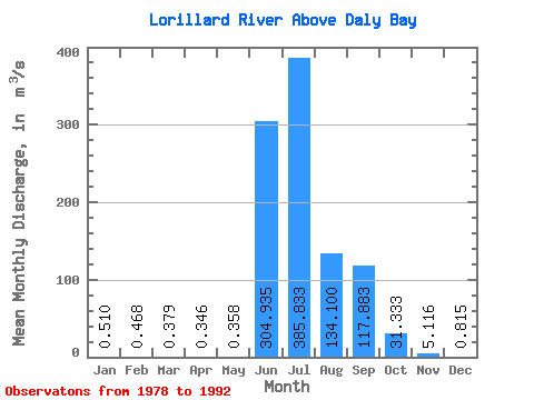
| Statistic | Jan | Feb | Mar | Apr | May | Jun | Jul | Aug | Sep | Oct | Nov | Dec | Annual |
|---|---|---|---|---|---|---|---|---|---|---|---|---|---|
| Mean | 0.51 | 0.47 | 0.38 | 0.35 | 0.36 | 304.94 | 385.83 | 134.10 | 117.88 | 31.33 | 5.12 | 0.81 | 81.97 |
| Standard Deviation | 0.61 | 0.59 | 0.57 | 0.56 | 0.55 | 234.43 | 212.44 | 108.19 | 91.86 | 15.77 | 4.07 | 0.90 | 25.05 |
| Min | 0.00 | 0.00 | 0.00 | 0.00 | 0.00 | 2.26 | 120.00 | 48.40 | 23.70 | 11.40 | 0.66 | 0.00 | 47.21 |
| Max | 1.50 | 1.50 | 1.50 | 1.50 | 1.50 | 772.00 | 842.00 | 375.00 | 355.00 | 58.40 | 13.50 | 2.24 | 126.22 |
| Coefficient of Variation | 1.20 | 1.25 | 1.49 | 1.60 | 1.53 | 0.77 | 0.55 | 0.81 | 0.78 | 0.50 | 0.80 | 1.11 | 0.31 |
 Return to R-Arctic Net Home Page