|
|
|||||||||||||||||
| Point ID: 318 | Downloads | Plots | Site Data | Code: 05BL021 |
|
|
|||||||||||||||||
| Download | |
|---|---|
| Site Descriptor Information | Site Time Series Data |
| Link to all available data | |
| View: | Time Series | All |
| Units: | m3/s |
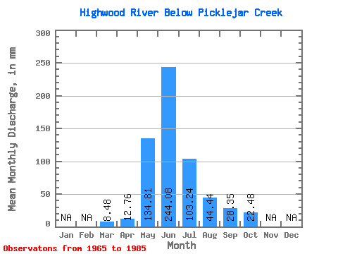
| Statistic | Jan | Feb | Mar | Apr | May | Jun | Jul | Aug | Sep | Oct | Nov | Dec | Annual |
|---|---|---|---|---|---|---|---|---|---|---|---|---|---|
| Mean | 8.48 | 12.76 | 134.80 | 244.08 | 103.22 | 44.44 | 28.36 | 22.48 | |||||
| Standard Deviation | 6.62 | 53.38 | 93.88 | 41.35 | 15.10 | 10.54 | 8.79 | ||||||
| Min | 8.48 | 8.13 | 50.72 | 93.08 | 33.27 | 23.13 | 15.59 | 12.78 | |||||
| Max | 8.48 | 22.58 | 233.31 | 437.89 | 175.29 | 84.80 | 58.91 | 51.12 | |||||
| Coefficient of Variation | 0.52 | 0.40 | 0.39 | 0.40 | 0.34 | 0.37 | 0.39 |
 Return to R-Arctic Net Home Page