|
|
|||||||||||||||||
| Point ID: 3131 | Downloads | Plots | Site Data | Code: 06FD001 |
|
|
|||||||||||||||||
| Download | |
|---|---|
| Site Descriptor Information | Site Time Series Data |
| Link to all available data | |
| View: | Time Series | All |
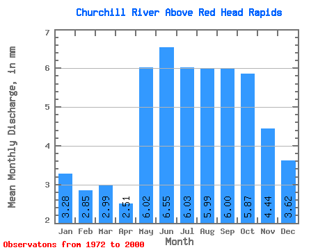
| Units: | m3/s |
| Statistic | Jan | Feb | Mar | Apr | May | Jun | Jul | Aug | Sep | Oct | Nov | Dec | Annual |
|---|---|---|---|---|---|---|---|---|---|---|---|---|---|
| Mean | 3.20 | 2.81 | 2.92 | 2.45 | 5.87 | 6.39 | 5.88 | 5.84 | 5.86 | 5.73 | 4.33 | 3.53 | 61.95 |
| Standard Deviation | 3.67 | 3.30 | 3.42 | 3.04 | 4.38 | 4.10 | 5.17 | 5.20 | 5.45 | 5.02 | 3.72 | 3.49 | 49.21 |
| Min | 1.08 | 0.72 | 0.69 | 0.64 | 0.78 | 1.82 | 1.23 | 0.80 | 0.58 | 0.71 | 1.35 | 1.23 | 20.23 |
| Max | 13.81 | 11.05 | 10.64 | 10.03 | 14.65 | 16.80 | 17.17 | 16.42 | 15.80 | 15.02 | 13.91 | 13.25 | 153.86 |
| Coefficient of Variation | 1.15 | 1.18 | 1.17 | 1.24 | 0.75 | 0.64 | 0.88 | 0.89 | 0.93 | 0.88 | 0.86 | 0.99 | 0.79 |
 Return to R-Arctic Net Home Page