|
|
|||||||||||||||||
| Point ID: 3131 | Downloads | Plots | Site Data | Code: 06FD001 |
|
|
|||||||||||||||||
| Download | |
|---|---|
| Site Descriptor Information | Site Time Series Data |
| Link to all available data | |
| View: | Time Series | All |
| Units: | mm |
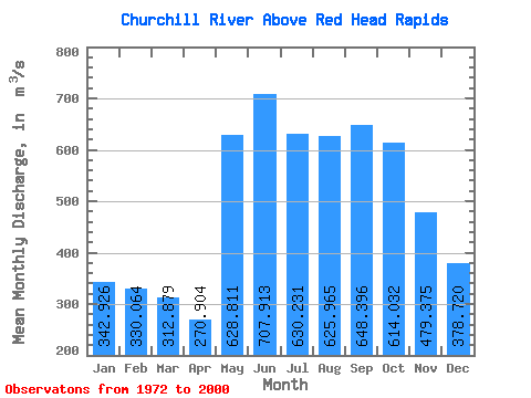
| Statistic | Jan | Feb | Mar | Apr | May | Jun | Jul | Aug | Sep | Oct | Nov | Dec | Annual |
|---|---|---|---|---|---|---|---|---|---|---|---|---|---|
| Mean | 342.93 | 330.06 | 312.88 | 270.90 | 628.81 | 707.91 | 630.23 | 625.97 | 648.40 | 614.03 | 479.38 | 378.72 | 563.41 |
| Standard Deviation | 393.11 | 388.17 | 366.30 | 336.34 | 469.32 | 454.06 | 553.51 | 556.94 | 603.79 | 538.35 | 411.44 | 374.38 | 447.51 |
| Min | 116.00 | 84.90 | 73.90 | 70.40 | 83.40 | 202.00 | 132.00 | 86.20 | 64.60 | 76.20 | 150.00 | 132.00 | 183.95 |
| Max | 1480.00 | 1300.00 | 1140.00 | 1110.00 | 1570.00 | 1860.00 | 1840.00 | 1760.00 | 1750.00 | 1610.00 | 1540.00 | 1420.00 | 1399.17 |
| Coefficient of Variation | 1.15 | 1.18 | 1.17 | 1.24 | 0.75 | 0.64 | 0.88 | 0.89 | 0.93 | 0.88 | 0.86 | 0.99 | 0.79 |
 Return to R-Arctic Net Home Page