|
|
|||||||||||||||||
| Point ID: 3119 | Downloads | Plots | Site Data | Code: 06DA002 |
|
|
|||||||||||||||||
| Download | |
|---|---|
| Site Descriptor Information | Site Time Series Data |
| Link to all available data | |
| View: | Time Series | All |
| Units: | m3/s |
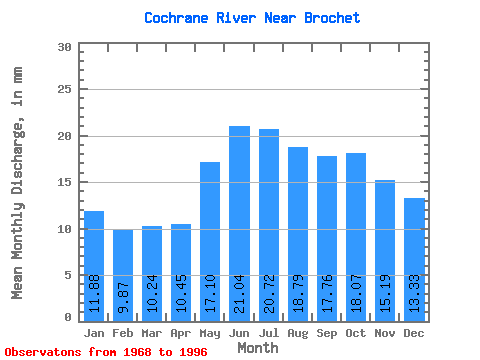
| Statistic | Jan | Feb | Mar | Apr | May | Jun | Jul | Aug | Sep | Oct | Nov | Dec | Annual |
|---|---|---|---|---|---|---|---|---|---|---|---|---|---|
| Mean | 11.88 | 9.95 | 10.24 | 10.45 | 17.10 | 21.04 | 20.72 | 18.79 | 17.75 | 18.07 | 15.19 | 13.33 | 185.71 |
| Standard Deviation | 1.89 | 1.35 | 1.42 | 2.01 | 3.54 | 5.70 | 5.75 | 4.61 | 4.19 | 4.37 | 3.37 | 2.52 | 26.93 |
| Min | 8.46 | 7.36 | 7.31 | 7.29 | 11.03 | 10.86 | 10.84 | 11.41 | 12.41 | 11.60 | 9.95 | 8.94 | 149.84 |
| Max | 16.03 | 12.37 | 13.11 | 15.70 | 23.76 | 37.69 | 34.51 | 31.68 | 27.02 | 25.27 | 21.54 | 18.39 | 265.96 |
| Coefficient of Variation | 0.16 | 0.14 | 0.14 | 0.19 | 0.21 | 0.27 | 0.28 | 0.24 | 0.24 | 0.24 | 0.22 | 0.19 | 0.14 |
 Return to R-Arctic Net Home Page