|
|
|||||||||||||||||
| Point ID: 3119 | Downloads | Plots | Site Data | Code: 06DA002 |
|
|
|||||||||||||||||
| Download | |
|---|---|
| Site Descriptor Information | Site Time Series Data |
| Link to all available data | |
| View: | Time Series | All |
| Units: | mm |
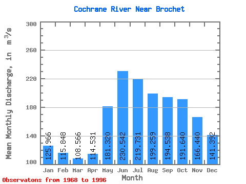
| Statistic | Jan | Feb | Mar | Apr | May | Jun | Jul | Aug | Sep | Oct | Nov | Dec | Annual |
|---|---|---|---|---|---|---|---|---|---|---|---|---|---|
| Mean | 125.97 | 115.85 | 108.57 | 114.53 | 181.32 | 230.54 | 219.73 | 199.26 | 194.54 | 191.64 | 166.44 | 141.39 | 167.11 |
| Standard Deviation | 20.04 | 15.68 | 15.10 | 22.07 | 37.50 | 62.44 | 61.00 | 48.87 | 45.95 | 46.39 | 36.90 | 26.72 | 24.23 |
| Min | 89.70 | 85.70 | 77.50 | 79.90 | 117.00 | 119.00 | 115.00 | 121.00 | 136.00 | 123.00 | 109.00 | 94.80 | 134.84 |
| Max | 170.00 | 144.00 | 139.00 | 172.00 | 252.00 | 413.00 | 366.00 | 336.00 | 296.00 | 268.00 | 236.00 | 195.00 | 239.33 |
| Coefficient of Variation | 0.16 | 0.14 | 0.14 | 0.19 | 0.21 | 0.27 | 0.28 | 0.24 | 0.24 | 0.24 | 0.22 | 0.19 | 0.14 |
 Return to R-Arctic Net Home Page